BBC Travel revered it as one of the world’s most dangerous roads. History Channel’s Ice Road Truckers hailed it as “a road where hell has frozen over”. Even locals do not travel this unforgiving highway of isolation, certainly not for leisure.
What could I, a stranger in the wild and foreign frontiers of Alaska, possibly know about driving the notorious James W. Dalton Highway then?
Especially in winter, when daylight hours are short, roads are treacherous, and temperatures can plunge as low as -22 degrees Fahrenheit (-30 degrees Celsius) or, as it happened in 1971, -80 degrees Fahrenheit (-62 degrees Celsius) – the coldest temperature ever recorded in the United States of America.
It was a death wish on my part.

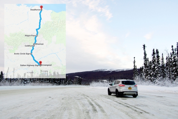
Warily, I stepped out of my rented Ford Escape SUV and eyed the welcome sign at the start of the James W. Dalton Highway, or simply the Dalton Highway, near Livengood, Alaska. The 414-mile (666-kilometre) mostly-gravel freeway is the only road access through the vast and remote central and northern Alaska. It was built in 1974 as a supply road to allow for construction of the 800-mile (1,288-kilometre) trans-Alaska pipeline that transports oil from the Prudhoe Bay oilfields near the Arctic Ocean to the port of Valdez in the south. The highway continues to be used today by truckers carrying supplies to oilfield employees stationed in the community of Deadhorse.
The Dalton Highway was never intended for tourists or the casual visitor and demands respect from anyone travelling through. The welcome sign, however, with its bold and cheery font, seemed curiously cavalier about it.

I checked my vehicle to confirm the essentials: spare tires, a first aid kit, and one giant flask of piping hot coffee. The satellite phone was working, and I had stocked up on food, water and gas earlier, just in case. Just in case I get stranded out there in the wilderness, I had thought. The highway was so far removed from civilisation with only three scantily populated towns – Coldfoot, Wiseman, and Deadhorse – along the way. Services were next to none on the road, particularly on a 240-mile stretch before Deadhorse without any restaurant, gas station, or worldly pleasures.
I tossed my iPhone onto the dashboard of the Ford Escape. I had lost cellular service, and would remain disconnected from the rest of the world for the next two days.
There was only the road, the occasional big truck, and the unending pipeline for company on one of North America’s loneliest roads.

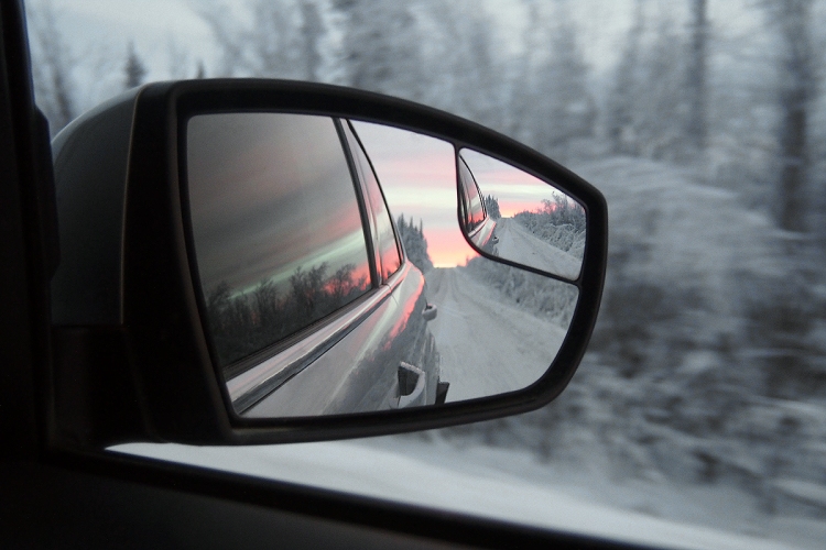
Heading north towards Coldfoot, the Dalton Highway was chaperoned on both sides by the boreal forest – also known as taiga, the world’s largest land-based ecosystem. Leaning in to whisper to one another in the silence, the towering coniferous trees bent under the weight of snow that enshrouded the evergreen needles beneath.
The road twisted and heaved with dangerous curves and steep gradients, easing only after the mighty Yukon River, Alaska’s longest waterway, while the extensive forest stretched far and wide in all directions.


It was beautiful, even with the cold, incongruous pipeline that meandered beside the highway.
The Ford Escape came equipped with a Citizens Band (CB) radio tuned to channel 19 for communicating with other vehicles on the road. Apart from giving way to trucks at all times, the CB radio is another key driving etiquette on the Dalton Highway and is used by truckers, pipeline security, state troopers, and just about anyone who finds themselves on the highway to inform one another of traffic, weather and road conditions.

Sometimes, the device would crackle to life and I’d listen to the indecipherable chatter between truckers. I made no attempt to join in – I wasn’t sure what to say – but found the voices oddly reassuring on a road where traffic was at times reduced to a lone fox wandering down the middle of the road. Unaccustomed to such desolation, I found comfort in knowing that I wasn’t all alone, if only for a minute or two.
The Dalton Highway is also the only road in Alaska that crosses the Arctic Circle, an imaginary line that has become an attraction in itself. For some, this was about as far north on the highway they would go, taking pictures of the Arctic Circle sign to memorialize how far they have travelled.

Except that wouldn’t be enough for me. I had to see for myself what this infamous 414-mile road would reveal and what I’d find at the end of it. Maybe that’s what driving the Dalton Highway meant to me: a representation of how far off the beaten path I would let my adventures take me.
It was dark when I arrived at Coldfoot, a town in the middle of nowhere that offered food and lodging. Calling it a “town” was an exaggeration, though – there were refurbished shipping containers for accommodation, a gas pump, a restaurant and a population of about a dozen. It was a truck stop, really, but for what it lacked, it more than made up for with a bar – the only place along the highway to get a beer.
As I knocked back a pint, I asked a staff about the weather and road conditions northwards to Deadhorse. A trucker – a broad-shouldered, white-bearded man in a cap – who had just driven south from Deadhorse overheard and was happy to share that the conditions were fine. But when he learned I was headed north the next day, he shot me a puzzled look.

“What for, young lady? There’s nothing up there,” he declared.
“Umm,” I gave an awkward laugh. What do you say to a man whose life and livelihood depended on the Dalton Highway, for whom it was never about seeking adventure or fun? “Just . . . umm . . . to see the scenery, I guess,” I spluttered.
“Well,” the burly trucker grunted, doffing his cap. “You drive safe.” He took another swig of his beer. “And watch out for them trucks.”
Continuing north on the Dalton Highway towards Deadhorse the next morning, the trucker’s voice echoed in my head. What for, young lady? The sun stirred from slumber, breathing light into the velvety night even as it remained below the horizon in the polar twilight. There’s nothing up there, he had said. The sky burned a deep blue before reddening into a soft purple glow that bounced off the snow-covered landscape and the cotton-like clouds above.
Maybe he was right, but here was already pretty incredible to me.


The boreal forests thinned out and in its place, jagged peaks soared high above the sweeping valleys. The corridor of mountains, known as the Brooks Range, sprawled from west to east into Canada’s Yukon Territory, its slate-grey massifs painted in white, rising against the melancholic backdrop of wintry skies.
Somewhere along milepost 235 laid the farthest north spruce tree, marking the transition between the arctic forest and the tundra beyond, where trees were unable to grow due to the region’s low temperatures and permafrost in the soil.

As I drove through the valley floor, I became conscious that I hadn’t yet seen a vehicle since I left Coldfoot that morning. Not even the occasional truck. There were just the mountains, and the uncanny feeling that these giant behemoths were watching me from afar. The world stood still, with only the arctic breeze playing with strands of hair peeking out from beneath my woollen beanie. I was all alone.
I was all alone, but, I wasn’t lonely. I didn’t need the truckers’ voices anymore.
Maybe I was getting used to the solitude on this deserted highway.

Just as I was becoming comfortable with the silence, the CB radio crackled as I neared the Atigun Pass, the highest year-round mountain pass in the state and the only one that cuts across the Brooks Range. Arguably the most challenging section of the Dalton Highway, the area is known for its harsh weather, heavy snowfall, and avalanche risks throughout the year. Climbing to an elevation of about 4,700 feet, the precipitous drops to the sides and the blinding whiteness of snow made it difficult to tell where the road ended and the drop to death began.
I slowed my vehicle to a crawl, not wanting to run off the road as many drivers before me had. The lights were blinking on the CB radio device and several voices were coming through, but I did not see any vehicle appear from around the bend on the steep incline up ahead.

They don’t know I’m here, I realized. Pulling over safely to the side, I took a deep breath – still unsure of what to say – and grabbed the radio’s microphone off its hook and pressed the push-to-talk bar.
“Umm . . . hello, this is a, umm . . . four-wheeler,” I announced nervously, trying to remember the terms used by truckers. “Heading . . . northbound? At the . . . umm . . . Ati-GOON . . . Ati-GURN . . . Pass?”
It must have seemed like I was bad with directions and pronunciation.
“Four-wheeler, you might want to stay where you are,” the radio hissed after a few seconds. “We have a convoy coming your way.”
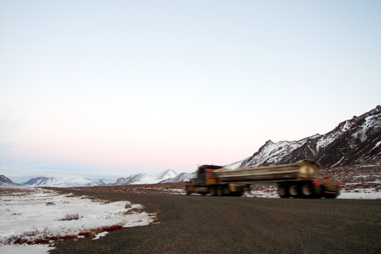
I lingered where I was and watched as an eighteen-wheeler came into sight, its massive tires racking up a cloud of snow and dust behind it. The monster of a truck manoeuvred downhill skilfully, followed by four other trucks navigating the descent in succession. It would have been suicidal to attempt driving past them on the slopes, especially if caught off guard, and I could appreciate how integral the CB radio was on the Dalton Highway.
As the eighteen-wheelers rumbled past my modest four-wheeler, the truckers gave me a friendly wave. I smiled and nodded, raising my palms up in acknowledgement. I felt like I was starting to fit in. Probably.
North of Atigun Pass, the highway entered the North Slope of Alaska, offering a dramatic change in landscape from the boreal forests and mountain ranges before. Leaving the Brooks Range behind, the terrain flattened into the arctic tundra. Dwarf shrubs, heaths, and lichens occupied its vast lands, but in the heart of winter, it was a desert of snow that spread out into the horizon like a thick duvet, smothering everything beneath.

It was as if I were a time traveller, having gone billions of years back to when the earth was a blank canvas and nothing existed; or perhaps an alien, having landed on an inhospitable, white wasteland in a futuristic capsule with four wheels. But despite the emptiness of the surroundings, there was something in the nothingness that left me feeling calm and at ease.
I felt, rather unexpectedly, at peace.
A fox glanced at me lazily from the side of the road before turning on its heels and scuttling under the pipeline into the white, barren landscape. Of course, I was never truly alone, was I? The road and the trans-Alaska pipeline were with me every step of the way, a reminder of human activity in a harsh environment that begs being abandoned, if not for the abundance of natural resources.

The North Slope, with its flat, exposed land, is often subjected to strong winds, lifting snow off the ground and blowing it onto the highway in a ground blizzard. I drove straight into one and visibility was drastically reduced – I could hardly see anything more than a few feet in front of the car. Nervously, I picked up the microphone of the CB radio.
“Four-wheeler, northbound. Strong winds and blowing snow. Poor visibility,” I initiated.
This time, I was confident and concise in my dispatch, but there was no one to congratulate me on my shrewd sense of direction and astute observations of the weather. The CB radio stayed eerily quiet. Worried about running the Ford Escape off the road, I kept my eyes on the highway and inched forward, gripping the steering wheel until my knuckles turned white. How long would it be before help came? I wondered. Maybe I should have brought a flare gun.
But just as abruptly as it began, the winds subsided and I could see far again. On the distant horizon, streetlamps and building lights flickered against the darkened sky. The screen of my iPhone lit up with a series of pings, vibrating noisily on the dashboard as messages started to stream in. I had cellular service, which could only mean one thing.

Deadhorse.
I have reached the end of the Dalton Highway.
Drill rigs and construction cranes made up the skyline of the town, while oilfield support facilities dotted the grounds of this remote community at the edge of the world. Trucks, like the ones I met on the highway, rolled by sluggishly at the speed limit of 15 miles per hour. A hotel billboard stood by the side of the road, an invitation to bed and breakfast for weary truckers and the odd traveller.
So this is what lies at the end of the notorious Dalton Highway, I thought.

Across the road, a man leaned against the side of his semi-truck, cigarette dangling from his lip as he tapped away on his cell phone. Grim, metal erections of the industrial town lined up behind him, cold and callous figures towering above the treeless, coastal plains of Alaska’s far north. A ptarmigan arced gracefully across the sky, its wings flapping quietly into the still of the night.
The burly trucker at Coldfoot was right. There’s nothing up here.
But, the Dalton Highway was never a journey concerned with its destination. It was always a means to an end, and the road in-between.

It’s the courage to take on one of the world’s most dangerous roads and to recognize the bravery of the truckers who drive it every day for a living. It’s the discovery of nature’s diversity – from the vast boreal forest to the rugged Brooks Range and the barren desert of the arctic tundra.
It’s about the 414-mile journey through one of the last frontiers of the world and finding peace within the solitude that Alaska’s Dalton Highway brings.
An earlier version of this story, titled “A Dangerous Road: Driving Alaska’s Dalton Highway”, also appeared on the Lifestyle section of 9tro Alliance.

